TREK FEE: ₹ 16,499 (Lohajung to Lohajung) + 5% GST
-
4800 M
-
Kathgodam
-
Autumn
-
Eco-Tour, Hiking
-
All meals during the trek
-
English, Hindi
-
6.5/10
-
12
-
65
Overview
Roopkund trek package is most famous trek in Uttarakhand due to iit’s mystery of old skeletons submerged in the lake. The mystery till date is unsolved though there are some theories about it. National Geographic has done documentary on its unsolved mystery. Roopkund trek is a high altitude trekking in Uttarakhand Himalayan range. Trek to Roopkund gives a chance to hike through some of the most beautiful meadows of Uttarakhand namely Didna, Pattar nachuni, Bedni Bugyal. Most common trail for Roopkund trail starts from Lohajung and ends at Wan.
Highlights
- Duration: 6 days of trekking; Walking from Lohajung to Roopkund and back to Wan. 8 days from Kathgodam to Kathgodam.
- Seasons: May/June (Summer/Pre monsoon) & September/October (Post Monsoon/Fall)
- Further Option: From Roopkund climb Junargali and continue to Homkund and finally to Ronty Saddle. Difficult long duration trek.
- Access: Trek starting point (trek base) is Lohajung, 220 Km from Kathgodam.
Itinerary
Pickup from Kathgodam in the morning and reach Lohajung (~ 2300m, 7500ft) which is 220 Km away. The journey may take around 10 hours with a break or two. The road is through the Kumaon region and mostly goes along wide spread valleys of Shivalik Himalaya. We cross Almora and Kausani on our way. From Gwaldam onwards the road enters in the Garhwal administrative region and the road is gradually winding and goes through the evergreen montane and conifer forests. The last stretch of the journey from Deval has considerable height gain. Our Roopkund trek base Lohajung is essentially transit point with a local bazaar and few lodges. Lohajung has one GMVN tourist lodge (TRH), one panchayat Tourist Rest House and 3/4 private hotels. All the major mobile networks have connectivity here. Night stay in Tourist Rest House/Lodge.
Our trek starts today morning. After breakfast we walk on the freshly tarred motor able road towards the village of Wan. After walking for an hour and half on the flat surface we reach Kulling at a distance of 6 Km from Lohajung. From here we take a right turn and descend through the village. Initially it is a narrow concrete lane inside the village and cuts along houses and firming fields till we reach a small stream. We descend further till we reach the river bed of Neel Ganga. We cross the cemented bridge and start climbing the ridge on the right side. The ascent is a moderately steep one and ends at the village of Didna (~ 2450m, 8000ft). The trail goes through the sub alpine evergreen forest. After climbing around two hours we reach the top of the ridge and see the firming fields wide stretch on the lap of the mountain with scattered houses here and there. Didna and Kuling village host the same set of people while the prior is used for the summer and monsoon while the later for winter. We reach by lunch time and enjoy the hot lunch after finishing the days trek. Total distance is 10 Km and may take around 4/5 hours. Accommodation at homestay.
Today we start early and trek to Bedni Bugyal (~ 3500m, 11500ft) via Ali Bugyal (~ 3450m, 11300ft), one of the most scenically beautiful alpine meadows in Indian Himalayas . We will climb the mountain which sets the backdrop of Didna village. After starting on the trail which goes out of the village we get a bifurcation. The trail on the right is longer but with gentle gradient and goes through a temporary settlement of the shepherds called Tolpani. The trail on the left is with continuous gradient but shorter. Eventually both the trail leads to Ali Bugiyal. The trails consist of thickly vegetation of Oak, Birch and Rhododendron trees. A trek during the late spring is full of red and pink varieties of Rhododendrons. Once we approach to the top of this mountain face the tree line recedes and the grassy slopes start from here. The climb may take 3 to 4 hours. After ascending this face suddenly a wide vista opens up and we are on one of the most beautiful meadows of Himalaya called Ali Bugyal. The far stretched green field clearly resembles the default wallpaper of Mcrosoft XP (if you remember he old days!) . As it is a table top, the clouds start to sell in after midday . Misty Bugyal has its own charm and feeling. We slowly walk on the gentle rolling slopes of the meadow. In summer and especially during monsoon this meadow is full with wildflowers in hues of blue, yellow and white. You can see grazing cattle and horses which will stay here till the end of monsoon. On a clear day one can see the peaks of Trisul and Mrigthuni towering straight. After crossing this Bugiyal we climb a small face and traversing for an hour reach another Bugiyal, our camping ground for the day Bedni. In the afternoon walk around the Bedni Kund and visit the small temple inside the boundary of the Kund. Clear weather will unfold mighty Trisul and Nandaghunti in front. On the other side we can see the panorama of Garhwal Himalaya like Neelkantha, Chowkhamba and others. Total distance is around 12 km and can take 6 to 7 hours. Camp overnight.
Today you will hike a short distance due to acclimatisation purpose. From today onward the oxygen starts reducing so we spend more nights before reaching the higher altitude. A short and easy walk takes us to Patar Nachuni (~ 3750m/12300ft). Total distance is 5 Km and may take 3 hours. We start by walking on the Bugyal and climb for half an hour to take the trail which is coming from Ali Bugyal. From here onward the road is almost flat till we reach Ghora Lautani. The road splits and we take the trail which goes to the right. Walking an hour on level ground we are at Patar Nachoni. The green fibre huts of the Forest Department is on the left hand side of the trail while the beautiful camping ground is around 200 feet down on the meadow situated in the right. On a clear day the view of Mrigthuni range is magnificent form this place. There is a small shop run by a local in season time inside one of the green hut. It offers basics like tea/coffee, noodles and biscuits. We camp for the night.
Today we trek to Baguabasa (~ 4300m, 14000ft) via Kailuvinayak(~ 4400m, 14400ft). Patar Nachuni is surrounded by meadows and occasional mountain tops. The top of the ridge going almost straight ahead is Kailu Vinayak. First we gradually climb the ridge for first 2 Km. Then the ridge turns right and rises sharply in next one and half Km. This is a steep climb and we gain almost 1500 feet within a distance of 1.5Km. The ridge goes zigzagging on the gravel. Slow but steadily climb this face without any hurry. The lack of oxygen may result to a headache. Once we reach the top there is small stoned temple of Ganesha with bells clinging to it. The deity is of black stone and thus the place got its name Kailu (Black) – Vinayaka (Ganesha). From here the vista in front widens and first view of the Roopkund area ( the depression of the lake) is visible on the lap of the ridge straight. It is truly mesmerising with glittering Trishul on right and bell shaped Nandaghunti on left at a stone throwing distance! We gradually go down on the rocky trail for another 1 Km to reach Bagua Basa. Total distance is 5 Km and can take up to 3/3 and half hours. There is a small cave on the right side of the well defined trail, and according to the legend it is the resting place or shelter of the Tiger ( Bagua -> Bagh/Tiger, Basa -> Home) that the goddess Nanda Devi rides. There are green fibre huts also here. The camping ground is also referred as Hunia Thar. This area is famous for Brahma Kamal, blooming in the monsoon. Fen Kamal (Pink) and Neel Kamal (Blue) are two other flower species which grow in this altitude. The flowers remain till early September. Being at an altitude of 14000 feet the area is rocky and brown while snow clad mountains towering in front. The area is notorious for snowfall. Snowfalls may start even in the month of early June or October. We tent for the night.
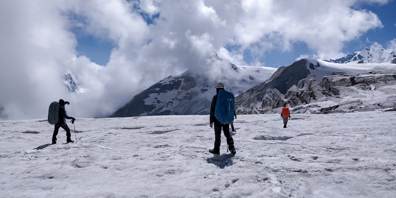
We start early in the morning by 5 am for Roopkund. It is a moderate climb to Roopkund for about 4 km but surely the altitude gain tires the body. Depending upon snow conditions it may take 2 to 4 hours to reach. Until mid of June the trail is covered with snow. During monsoon to late September snow will be much lesser. The trail is well defined but on snow it is difficult to locate. From Baguabasa camping ground the trail is a traverse first till we reach a place called Chhiria Nag meaning staircase formation like a snake. From this point the climb is moderately steep and one final steep climb on rock leads us to a flattened trail. Due the Nanda Raj Jat (Yatra) in 2014 the trail has been maintained and in well condition. From here we can see the depression ahead which is our destination, Roopkund (~4800m/15750ft). We spend some time clicking the photos and offering puja to the small temple of Goddess Nanda Devi. The shallow lake has remains of skeletons which are almost 1200 years old! There are still remains of semi decomposed torsos on the other side of the lake, which is a permafrost area. Depending upon the weather condition/time and team condition we may decide to attempt Junargali Pass (~ 4950 m, 16240 ft). The pass is between the ridges joining two low altitude peaks, Chandaniya Kot (on the left) and Kali Dang (on the right). Without snow in September it will take 30 to 45 min to reach the top. From Junargali, Nanda Ghunti and Trisul massifs are magnanimous. The depression between Bethartoli Himal and Nanda Ghunti is the famous Ronty Saddle. We return on the same trail to Baguabasa. Descend on a steep trail is often tricky comparing to that of ascent. We climb down till Baguabasa and then almost on a level ground till Kailu Vinayak. We continue our descent till we reach Patar Nachuni. A long days trek ends at the lush green camping ground. Total trek distance is around 15 Km and may take 8 to 10 hours depending upon the snow condition. Depending on the team condition we may return to Bedni Bugyal. Camp for the night.
Today is a long way descending till Wan. From the camping ground a small climb takes us on the main trail. Now we follow the same path back. This feels like a cakewalk after the strenuous day before. We continue our trail back to Ghora Lautani and then to Bedni Bugiyal. After reaching Bedni camping ground we take the trail on the right and is different from the route by which we reached Bedni. Now we go down on the Bugiyal while we see the green fibre huts on our right. After going down for a while the road splits. We take the right hand side trail which goes down and slowly we enter into the tree line again. In few places the gradient down is steep and goes through the forest all the way. Avoid taking the shortcuts as it may hurt your knees. After descending for an hour we reach an opening inside the forest and called Gahroli Patal. We continue going down till we reach the river bed of Neel Ganga. From here we climb to reach the top of the Wan Village which is called Ran ka Dhar. Now we enter into the village of Wan and continue to descend. The village is stretched on both sides of the mountain and indeed huge comparing to normal Himalayan villages. Finally we reach the road head to take the Jeep. Total distance is 17 Km and takes around 7/8 hours. It is around an hour from Wan to Lohajung by car and the road road is bumpy at places. Enjoy the evening at Lohajung while sharing the fresh memories of the trek. Night stay in Tourist rest house/Lodge.
In the morning start from Lohajung to Kathgodam by car and reach in 10 hours. Roopkund trek tour ends here. You will reach by 7 pm in the afternoon. You can book tickets accordingly.
Cost
The Cost Includes
- All meals during the trek. Regular Indian style nutritious vegetarian food during the trek (including occasional eggs), breakfast packed/hot lunch (depending upon the time you reach a campsite), snacks, dinner along with coffee/tea/soup.
- Excellent Trekking Guide, who will be a local to this particular area and has profound knowledge of the trekking trails around.
- Specialised Cook, Support staff, Porters/Packed Animals for carrying the central logistics of the trek.
- Stay in tents (3 persons dome or ridge shaped tents) on sharing basis during the trek.
- Camping equipment like Sleeping bag, Carry mattress, Gaiters, Micro spikes/Crampon. (Bring your own sleeping if you have a high altitude specific personal Sleeping Bag. This is always better for hygienic reasons.)
- Kitchen tent, dinning tent and toilet tent as required during the trek.
- All permit fee, camping charges, forest levy required for the trek.
- Basic Medical & First Aid kit.
The Cost Excludes
- Transportation from Kathgodam to Lohajung and back to Haridwar/Kathgodam (Rs 1500-1800 per persons both ways for the pick up and drop)
- We assume that you will carry your personal Rucksack/Backpack with all your personal belongings. If you want to offload your Rucksack and be carried by our Pack Animal/Porter then you need to pay additional ₹ 1500 for the entire duration of the trek. The Rucksack should not weigh more than 10 Kg.
- Any tip/gratuity to the HXT supports staff.
- Anything is is NOT mentioned in the “Inclusions” or personal in nature.
Map
Booking:
We assume that you have read and understood our “Terms & Conditions”
Terms & Conditions – Himalayan Xpress TrekkerName/terms-and-conditions) before Booking a trek/tour.
To reserve your place in a scheduled Fixed Departure trek or a Customised/Private trek pay 30% of the TREK/TOUR FEE as the initial “Booking Deposit”. You can pay by Net banking/Draft/ Cheque/ Credit/Debit cards. This will ensure your participation in the desired trek and we will reserve your place in the scheduled date. You need to pay the remaining amount at least 15 days before Trek Starting Date.
If you book a Trek/Tour before 14 days or less from Trek/Tour Starting Date, you need to pay the full TREK/TOUR FEE.
Cancellations:
“Booking Amount” i.e.30% of the TREK/TOUR FEE is Non-Refundable at any stage.
If in case you are not able to make it due to unavoidable reason(s), we provide you avery flexible choice of Shifting to another trek within next one year. One year is counted from the starting date of the trek/tour you booked initially with us.
In case you postpone your trip you need to inform minimum of 15 days before the trek/tour starting date. (Though we suggest to inform us earlier if known)
In case you postpone a trek/tour before 15 days of the scheduled Trek/Tour Starting date or prior, you may shift to another group of the same trek/tour scheduled in the same season or within next one year. You may shift to another suitable route also. For changing any, you need our approval first. Your request must be in written communication through your registered email with us.
If you cancel/postpone a trek/tour from 14 days to 8 days before tour starting date, your Booking Amount is Non-Refundable. We will not take any request of shifting dates. We will charge 50% of the amount as Cancellation Charges and process refund of remaining 50%. You may also shift to another group within next year but 25% Booking Amount will be deemed as Cancellation Charge and the rest amount will be transferred to the shifted group.
If you cancel a trek/tour 7 days (i.e. a week) before Trek/Tour Starting Date or later, there will be NO REFUND.
In case of any unforeseen incident including but not limited to natural calamities like flood, earthquake, landslide, forest fire or any political unrest, if we are compelled to cancel the trek/trip, you will be entitled to redeem
If you need more clarifications write in to rameshpanwar2010@gmail.com